ELS911 is a school safety infrastructure project — delivering precision facility mapping in 2D and 3D, captured with best-in-class LiDAR, NENA/NG911-directed wayfinding for emergency response agencies, and SOC 2‑certified emergency response systems that every K-12 facility needs.
From initial site assessment through ongoing certification, ELS911 delivers the tools and documentation that keep your school community protected.
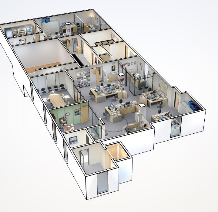
Captured with best-in-class LiDAR, survey-grade 2D and 3D plans of every room, corridor, entrance, and utility shutoff — formatted for first responder use and digital distribution.
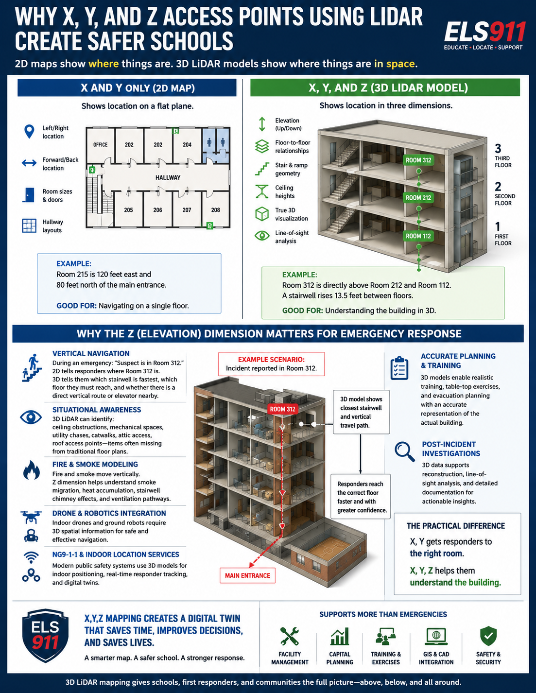
Room-level location accuracy during any emergency event — giving responders the exact position of personnel, threats, and critical infrastructure the moment they need it.
Structured, actionable emergency plans developed with your administration and aligned with local law enforcement and fire department protocols.
Training and certification programs for administrators and staff — so your team is confident and prepared, not just compliant on paper.
Full documentation packages for state and federal compliance requirements, including Uniform K-12 Mapping Act filings and annual re-certification records.
NENA/NG911-directed signage installed throughout your facility, with floor plans pre-loaded for local police, fire, and EMS — so responders find your spaces, not discover them mid-incident.
Survey-grade 2D floor plans and navigable 3D dollhouse models — captured with best-in-class LiDAR — giving administrators and first responders a complete, accurate picture of every space in your facility.

A single, standardized vocabulary for every space — pre-mapped to your floor plans and shared with first responders before any incident.
Accurate information. Faster response. Safer communities. A structured, proven engagement that gets your facility mapped, certified, and integrated with first responders — with minimal disruption to your school day.
Assess current floor plans, maps, and emergency response plans.
Installation of ELS911 NENA/NG911-directed wayfinding for first responders.
Best-in-class LiDAR scanning of all exterior and interior spaces.
Maps, floor plans, and 2D and 3D models created conforming to NENA/NG911/AHJ recommendations.
ELS911 certifies maps and floor plans and delivers to PSAP, first responder agencies, schools, and insurers.
Training on the ELS911 process, utility, and access — for administrators, staff, and responding agencies.
ELS911 treats your school facility the same way engineers treat bridges and power grids — as infrastructure that must be documented, maintained, and accessible to responders at any moment. A school without a current, accurate floor plan is infrastructure without a blueprint.
Build Your Infrastructure →Best-in-class LiDAR-captured, precision-mapped plans of every space — the foundational layer of school infrastructure.
Your maps, available to local police, fire, and EMS before an incident — not discovered for the first time during one.
ELS911 updates your maps as your facility changes — keeping documentation current, certified, and compliant.
Certified annually, including independent SOC 2 Third Party Certification. Your data and documentation are protected at the highest standard.
ELS911 delivers physical and digital documentation — from posted emergency maps and wayfinding signage installed throughout your facility to precision floor plans used by first responders.


ELS911 works with every type of educational facility — from single-building elementary schools to large multi-campus vocational centers.
Elementary, middle, and high schools — public and charter.
CTE and vocational institutions with complex, multi-use facilities.
Private schools seeking voluntary compliance and best-practice safety standards.
District-wide mapping programs covering multiple campuses under one coordinated plan.
ELS911 is making an impact across Pennsylvania — partnering with schools, first responders, and legislators to advance safer educational environments.
The Uniform K-12 Mapping Act continues to gain support, requiring standardized facility maps accessible to first responders at all K-12 institutions across the state.
New research confirms that 70% of school safety civil suits cite documentation and response failures — making certified emergency planning a legal imperative, not just best practice.
Growing demand from school administrators and law enforcement has ELS911 expanding its assessor team and geographic reach across central Pennsylvania and beyond.
The Uniform K-12 Mapping Act requires schools to maintain accurate, standardized facility maps accessible to emergency responders. ELS911 was built specifically to help schools achieve and maintain full compliance — efficiently, and without the guesswork.
Innovation Park at Penn State
200 Innovation Blvd.
State College, PA 16801
Monday – Friday, 9am – 5pm EST
